


Southeastern hills. Near Artà

"Rising up into view is Son Servera at the foot of a grey hill with a rocky peak, joining others of decreasing height on the left and a type of plain on the right, crowned by some disperse windmills. The place is flat and crossed by a small creek. It lacks any type of special grace and has 1,577 inhabitants. We see vineyards and almond and prickly pears planted next to the houses. There are 391 houses total, of which 10 have been abandoned. 51 have two stories, while the rest just one. They have half-point or segmental arch portals. The church is found in the plaza bearing its name.
The temple is dedicated to Saint John the Baptist and has a side entrance, a covered square tower with two ogive windows on each side and consolidation stanchions. Its crest is at 92.3 m above sea level. The interior has a barrel vault ceiling held up by four columns and half-point arches. There are five side chapels with Baroque altars. One of these chapels is used as a side entrance as mentioned. In the ceiling we can read the dates, 1699 and 1833. The entrance is topped by a gallery for the choir and organ with two chapels on the side. The main altar is the same one that once belonged to the Sant Nicolau Vell or Sant Nicolauet Church in Palma. It’s presided over by an image of Nuestra Señora del Rosario (Our Lady of the Rosary), guarded by other images on the sides representing Saint Peter and Saint John the Baptist, respectively.
Capdepera only has 1,419 inhabitants and 495 houses, 19 of which are deserted. Due to its proximity to the sea, the majority of its population consists of fishermen and sailors. Its location is certainly beautiful. A long road, the only surfaced one, runs through the entire town. At the start it’s called Carrer de Palma, though its name changes to Carrer del Port on the other end. It also has two small plazas: Plaça Major, not very pretty, and Plaça Vella with a beautiful hackberry. Excepting 19 houses with two stories, the rest only have one. Their entrances usually consist of half-point or segmental arches and a rectangular door, at times preceded by a trailing vine. They all have an angled drain under the roof to gather water, as this place lacks water. This circumstance is compensated, however, by the abundance of cisterns.
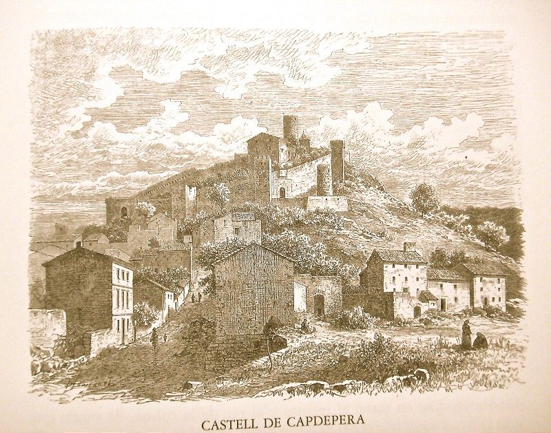 The fortress, with stonework and sandstone walls, is triangular in shape and has five towers made of sandstone blocks and formed at an angle. One has stones embedded in its corners, though the rest is stonework. All the towers have a half-point barrel vault ceiling except the one next to the Rei En Jaume gateway which has a pointed ceiling. The one next to Portalet is quadrangular in shape but forms a right angle on one of its edges. A corridor of stone tiles surrounds the entire complex and is attached to the wall to be able to access the loopholes in case of attack. The fortress has two doors: the tower-shaped Rei En Jaume gateway with battlements found in the corner of the triangle and with a segmented dome and exterior opening consisting of a half-point arch. The same is true of Portalet, the second gateway, though found between two towers and also quadruple battlements up top. To the right of the paved path crossing it are the old dungeons, near which there are still today some small, semi-ruined houses though some are occupied. This road winds until reaching the Governor’s house attached to the now disappeared barracks, home today of exuberant prickly pears. There is a hackberry at the door to the Governor’s house, the other rising up alone amidst the ruins of other buildings. From its location, we can completely see the town below us. Not far is the old parish church, today roofless, and on which we can read the date, 1770.
If we leave Capdepera taking Carrer del Port, this good road leads us to nearby Cala Ratjada, the town’s main dock. Our path takes us past sandstone and gravel quarries before beginning a soft descent with some curves, at the same time providing us beautiful views of the sea with Menorca Island in the distance and, looking back, Capdepera. After crossing some fertile tilled fields, spotted here and there with pine and fig trees, and then a stretch populated by mastics and fan palms, we come to Cala Ratjada.
The path leading to Talaia de Son Jaumell located at the top of l'Agulla crosses the plain behind Cala Ratjada planted with some vineyards. It then crosses over a small sandy hill, noteworthy before the attack of the powdery mildew fungus for its lush vineyards, and then enters a pine grove overlooking the Ses Covasses beach. A steep path climbs up the slope of l'Agulla, a hill on which only reeds seem to be comfortable. From here we can take in all of the beautiful Sa Mesquida beach with its “arenal” (large sandy area) and plain reaching up to the white Sa Mesquida house, the three capes of the small Matzoc cove, with Faralló and Bec de Ferrutx, and Formentor Island in the distance. Behind Matzoc and separated by the peaks of Ferrutx is a county of rolling hills extending towards Albarca.
Talaia de Son Jaumell is an old signal tower that is slightly conical in shape. It has an external wooden staircase and an optical telegraph held by four iron chains.
We descend down the smooth side of the slope on the other side towards the Sa Mesquida beach.
We cross over the Torrent de Sa Mesquida creek with a well and trough next to false pepper trees and exit along the top part of Sa Caleta to head down the sandy slope of Cala Torta. There we also find Cala Mitjana with a beautiful small house amongst pine trees on the right, overlooking the sea, and lastly Matzoc.
We climb the first escarpment of the nearby mountain range, cross over a hollow with pine trees and come to the new Albarca house surrounded by a profuse number of prickly pears.
The view from the Ses Coves house up high on some escarpments is beautiful. It’s an elongated country house, with a half-point arch doorway and surrounded by fig trees and beautiful plantations of mixed olive and carob trees below.
We can begin our return trip to Capdepera from this house and Duaia Nova, one of whose houses has numerous prickly pears around it and offers a no less splendid view.
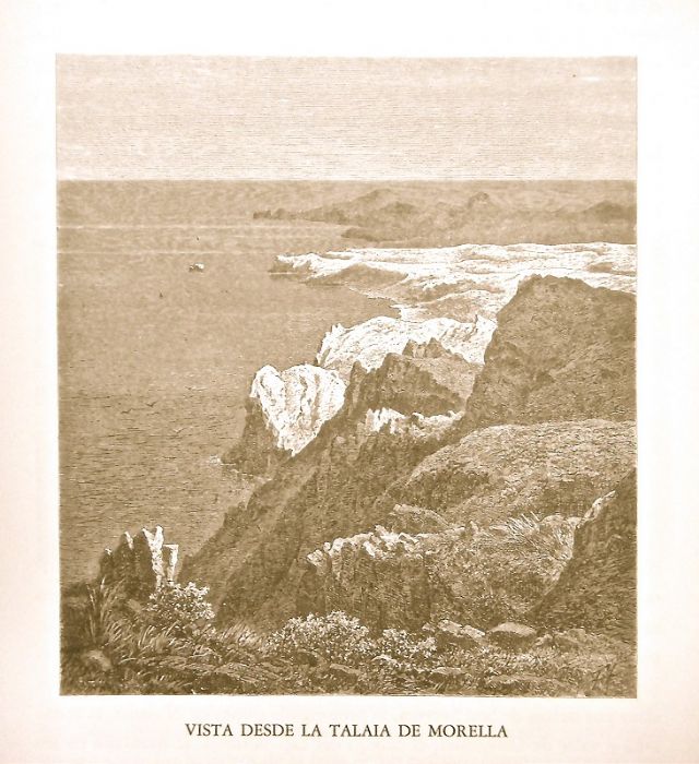
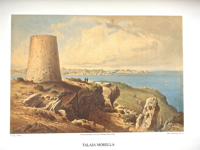
A surfaced path takes us from Albarca to Matzoc, and over a hilly terrain we come to the Sa Font Salada beach. There, up a steep path, we come to a plain, Es Pla de Ses Bitles, bordered by the Puig de Ses Fites and Puig des Vell Marí peaks, and, beyond the valley of Galleric, by Talaia Morella and Coll Paredat. From the latter we overlook Cap de Pera y Agulla and can see the neighboring Menorca.


A bit farther down, towards the sea, is Sa Font de Sa Vaca. Along a slope which quickly flattens into a hill we climb softly towards Talaia Morella, a conical tower rising up to 432.27 m above sea level. It has a small rectangular door up high protected by battlements. It was built in 1604 but abandoned as a watchtower in 1629. It was later reinforced upon request of Artà’s citizens given the possibility of an attack by the Moors. The view provided from the tower is certainly impressive. It encompasses the cape of Formentor and then the entire Puig d'Inca plain up to Randa, the heights of Na Xeroi and the Betlem house and s'Ermita, the crags of Mount Betlem and the Freda watchtower communicated by means of a long pass to the conical Puig Porrassar peak and reaching, lastly, the hills surrounding Capdepera to La Agulla and the n'Amer Point sticking out.
Once leaving behind the path running from Albarca to return to Artà, we continue on our journey through earthy terrain until reaching Verger. Some pine trees fight to establish themselves in this place, the almost exclusive domain of reeds and dedicated to crops on its flattest part. We surround a promontory and leave the so-called Roters path heading towards Artpa. We thus come to the foot of Puig de Ses Murades, from where we can see the Verger house at the end of the valley which seems very steep from here.
A rocky path climbs up to Puig des Corb which, along with the conical Porrasar hill at its side and the haughty Freda watchtower, closes off the valley of Alqueria Vella which begins in the steep Comellar Des Pinar and populates itself with olive trees as it advances. Through the Coll des Garballó pass, we can see the valley of s'Alzinaret up to the distant Morella watchtower between those of Freda and Puig de Porrassar. We can once more see Alqueria Vella with its small, modest and picturesque house in the middle of an olive tree grove.
Returning to Coll del Garballó, a path takes us along the top part of the valley of Alqueria Vella to the hermitage.
 Crossing over a hill, we see Alcúdia Bay and the town spreading out at the base of a rosary of mountains. Farther down we come to the so-called Font des Capellà, the spring’s water dripping amongst ferns at the base of a crag crowned by an enormous mastic. This point offers a magnificent view of Alcanada, Alcúdia and the nearby hermitage. In the small valley immediately below is the recently constructed Betlem house.
The new hermitage was inaugurated on May 10th, 1818. To its left is the church with a small atrium, a surrounding wall and a bench on the right. A solitary cypress guards the door consisting of a limestone lintel in which we can read the inscription: “Solitudo sive eremitarum anachoretarum”. Above is a sundial and a small window serving to let in light along with a rosette above. A single roof covers the dome and the arms of the Latin cross which make up the church. Its interior consists of a small nave with rustic columns in the corners which begin on four half-point arches and support the oval dome. The latter is decorated with a recent fresco of the Virgin Mary’s Coronation.
The columns’ bases are made of beautiful stalagmite stone; the upper molding of black marble with white streaks is from Artà. Both arms of the cross house their respective altars, adorned at the base with stalagmite rock as well. The main altar is made of marble and jasper from the island.
We turn our attention now to the last foothills of the rough terrain in the southwest part of the county. Heading towards the plain, Carrer del Figueral overtakes the Artà road to Son Fortesa, offering beautiful images of the town behind us. It runs along slightly rolling terrain populated by almond and fig trees, with olive trees on the taller parts, all to seek out Calicant.
In a short time we come to the first foothills of Bec de Ferrutx at the base of the conical s'Esquerda hill which rises to 382,14 m above sea level and the Puig d'Alpara peak above it to the left with its 487.54 m. At the base of the latter is the beautiful white Carrossa de Villalonga house. We climb down once more along the rolling terrain populated by olive, fig and some carob trees until the place called Ses Carbones, a hollow in which the presence of norias stands out. Continuing along the path, we come to a lush Holm oak grove forming a type of avenue and then an exuberant olive tree grove through which we come to Son Fortesa at the top of a small hill.
Beyond Son Fortesa and after crossing the stream, another branch of the path takes us back to the main road. Carrossa, which is not far away to our left, is a house with seven windows on its main facade, occupying a dominant position over the land. The path climbs up through a pine tree grove between Puig del Pare and Bec de Ferrutx until reaching Coll de Morell, a privileged lookout spot over the plain of Artà and the tall valley of Morell with the beautiful estate of the same name on one side and the entire plain on the other side bordered by the Serra range in the distance. There is an “hort” (garden) in the valley with elms and orange trees. At the end of which, the presence of cypress, laurel, elm and black poplar trees stands out. The majestic Morell house belongs to the Marquis of Bellpuig, though it was once one of the old farmsteads. Today it has a covered terrace supported on massive buttresses, an old “clastra” (cloister) with steps leading up to it and an arched entryway.
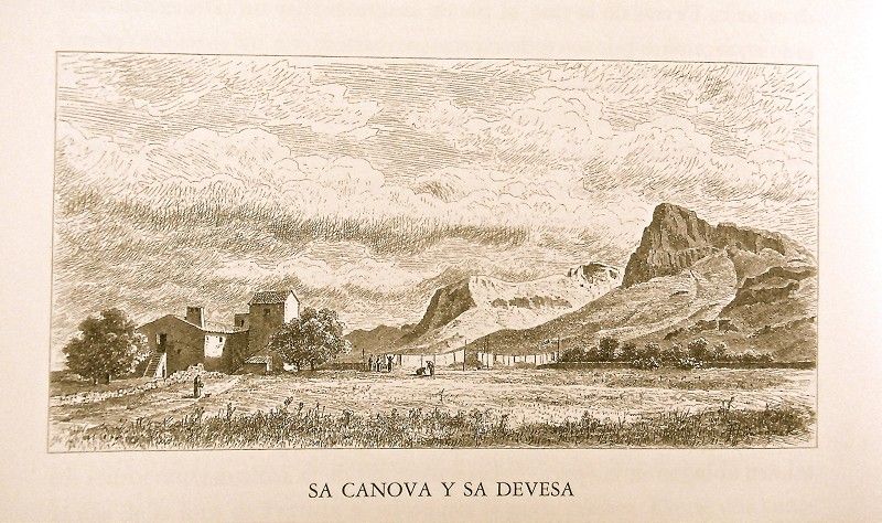
 If we take the main road again, offering a pretty panoramic view backwards of Morell and the majestic Bec de Ferrutx, we soon begin descending along a hilly terrain populated by olive trees in tight rows and then reach the plain. The landscape, with the chain of mountains in the background and the conspicuous Cap de Formentor, is impressive. We pass by an old windmill and, to the right, just at the base of fantastic Ferrutx, we see Sa Devesa with its old abandoned windmill. Shortly after we come to Sa Canova, leaving to the right the ravine with the same name and its exuberant plantation of fig trees. Sa Canova is a small house with a half-point doorway and covered tower made of stone blocks.
With Sa Canova behind us, to the left we pass by Rafal Pai and begin a soft descent towards the “pinar” (pine grove) not far from which is Ses Pastores. From here, the double peaks of Puig Major de Lluc and Puig de Sóller seem to form a grand pyramid, Mallorca’s singular crown. Large mastics, some young pines and numerous wild olive trees represent the vegetation. To the left is Es Doblons, a fairly large and reddish house which is on the other side of the creek; then comes Es Cabanells Vells.
Immediately after crossing through a small wood, the majestic Son Serra de Marina with its rounded tower and windmill to the right comes into view.
Worth seeing is the beautiful granary or “quartera” which is divided by four arches into two corridors with three stretches each. The beautiful bodega is below and, like the “quartera” above, it has a sandstone ceiling. The bodega holds two large barrels and “botes congrenyades” barrels."
Archduke Ludwig Salvator of Austria. Las Baleares por la palabra y el grabado. Majorca: The island. Ed. Sa Nostra, Caja de Baleares. Palma de Mallorca. 1982.
Photos