


From Capdellà to Andratx

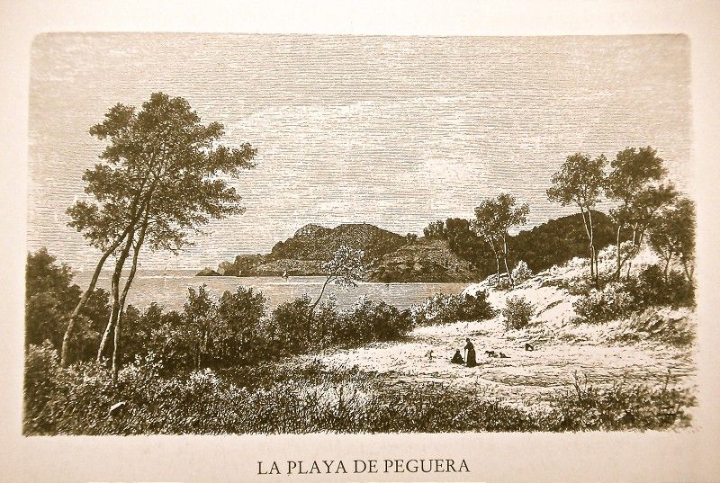
"From Es Capdellà, a paved path connects with the main road, here parallel to the stream, there moving away from it. To our right are the tall desolate peaks of Coll d’En Esteva, with barren, rocky summits and terraced hills with olive and pine trees. The path runs next to these foothills, with the Torrent’s bed to the right, here lined with marcial reeds and there with luxurious fig trees. Down the path through rough terrain, we see the Possessió de Peguera estate at a certain distance at the base of a hill with olive and pine trees. We then come to the road to Andratx where the two aforementioned ravines join, a point known as Pas or Coll de Sa Mula.
 A small bridge allows us to cross over a hollow and freely access the Santa Ponça plain. It is somewhat rocky but well taken advantage of, with almond, fig, olive and carob trees planted, in addition to young pine trees. The already described mill next to the Santa Ponça house which we have just left at a certain distance to the left stands out with its blades above the trees. It is visible from very far away. The view encompasses Santa Ponça Bay.
To the right is the Pegueras’ house with its extensive vineyards at its feet. It is a majestic construction with four windows on the first floor and seven on the ground floor. It has a large inner patio with a cistern in the middle. The “tafona” flour mill consists of two “bigues” and a press. In front of the house, a spacious plot offers a beautiful view of the rough Calvià Valley with its reddish mountains, the church and the Toràs’ house up high on a hill.
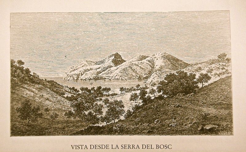 The path climbs up a bit towards the lush Cap Andritxol Cape, also known as Serra del Bosc. It then climbs and looks over the following inlet, surrounded by the peaks of Cala Llamp cove. Near the shore, at the base of the path and under a clear curve is the Possessió de Camp de Mar estate, previously belonging to the Marquis of La Romana and today to Son Fortuny.
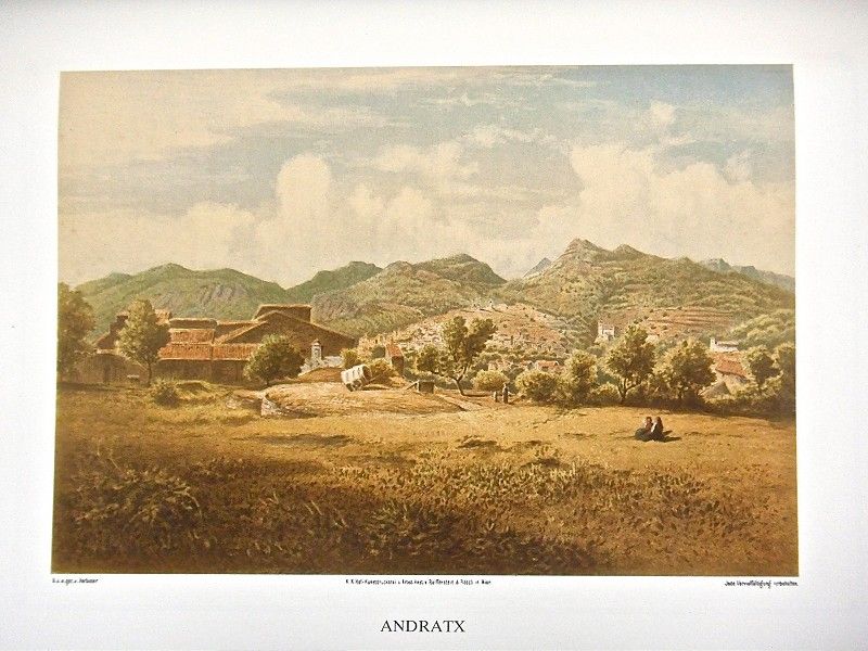
 The road descends softly almost in a straight line towards the beautiful Andratx Valley. We can see the town’s houses and church already from a distance, its profile dotted by some isolated windmills at the feet of some hills, at times barren, at others covered in pines. The prettiest image consists of the houses in Can de l’Aigua. They’re grouped together on the left, very close to the road, with a sloped covered tower. Carrer de Cerdà Street takes us into the town. Andratx, the ancient Andrachium for the Romans, is one of the most welcoming towns on Mallorca. On a hillock towards the east is the parish church, one of the oldest and thought to have been founded along with the town on the remains of an old Roman settlement after Jaume I’s conquest of Mallorca. In Pope Innocent IV’s bull of 1248, the church is already mentioned by the name of Santa Maria de Andratx. Its simple exterior features a tower to the right with a pyramid-shape crest, its point rising to 132.84 m above sea level. The church’s interior is fairly spacious, measuring 48 paces long. Seven columns attached to the wall hold up the same number of arches from which some ribs cross simply in the keystones featuring images of saints. A choir illuminated by a rosette dominates the entrance. A smaller rosette opens above in the main altar chapel. Three steps lead to the latter which includes an image of Nuestra Señora de los Ángeles (Our Lady of Angels), the town’s second patron saint. There are five chapels on either side, the first on the left corresponding to the entrance while the one on the opposite side is the largest of all. In the chapel dedicated to Blessed Catalina Tomàs, we can see her statue, sculpted by Adrià Ferrà.


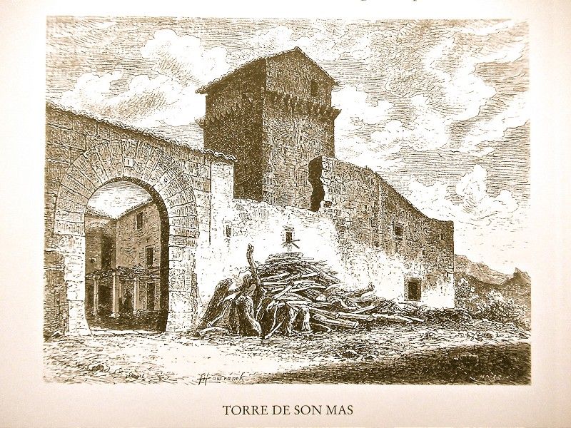
Very close to Andratx still, we find the majestic Possessió de Son Mas estate on a hillock. It belongs to the Marquis of La Romana. A small chain of hills, here and there covered in pines, serves as the backdrop. A road through a clearing planted with olive trees and winding through groups of prickly pears leads to the old and picturesque house. On its western facade, a quadrangular tower, blackened with time, rises up. It has a cover on two sides and a Gothic window on the southern part. In the patio is a grapevine held up by octagonal sandstone columns. In the center is a cistern.
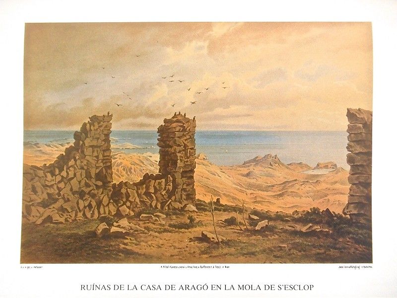
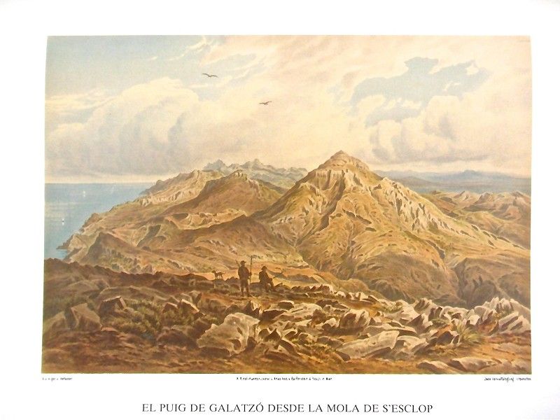
Occupying a dominant position is the majestic s’Alqueria house, with a rounded-arch entrance and a portico which progresses with arches forming matrixes. The walls seem whitewashed and have small stones inserted. In middle is a well with a vine held up by four square columns with beveled edges. From here is the best place to head to Mola de s’Escrop or Esclop mount, which is where our next steps will take us. To this end, we pass through Coll Baix pass after climbing up a steep rocky hill. From the peak we can contemplate the large pine forest of Alqueria, Andratx Valley, the port and Santa Ponça’s inlet, along with a part of Cap Malgrat and Cap Toro capes. In the background we find the sea and the distant Ibiza. Before us is the path leading to Serra del Vent, while our path continues amongst pine trees and reeds. The vegetation disappears almost completely all at once, excepting the reeds and the underbrush. Along a winding, gravel path we come to the pass between the peaks of Mola, called Coll del Ciuronar, a privileged spot with views of the nearly pyramid-shaped Puig de Galatzó, the following peaks up to Puig Major and the vast plain which seems to extend to Cabrera.


On the north side we reach the peak a bit higher up, some 150 meters away and occupied by the Aragós’ small house and spotted here and there by small pyramids where signal flags or rods have been placed for geodesic tasks. The peak is 927.27 m above sea level. From here we can see the d’Estellencs Tower, the promontory towards Planícia, the wide plain with different groups of houses, the Cap Blanc cape and Peguera’s coast.
From Andratx, if instead of the mountains we choose to go to the sea, we can take a fairly good path. Shortly after leaving the town we pass by the Son Esteva garden of orange trees and vegetables, on the left and a bit higher up.
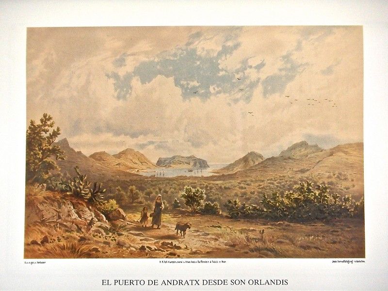 We leave Puig s’Enfront to the left, the peak closing off the valley and on whose foothills, protecting it, we find the Possessió de Son Orlandis estate surrounded by prickly pears and its old tower with arrow-slits and a flat dome entrance bearing an ancient coat of arms on the facade. The large house, with an enormous and vigorous trailing vine at its entrance, also has a small exterior staircase. The property is under an emphyteusis lease and, as of today, belongs to several owners. It is the house which perhaps occupies the best spot in the area around Andratx.
After Son Orlandis comes a completely flat valley, used almost entirely for crops, with large plantations of fig trees, their large branches held up by poles. It’s bordered by soft, well-differentiated hills. The view offered from here is truly pretty.
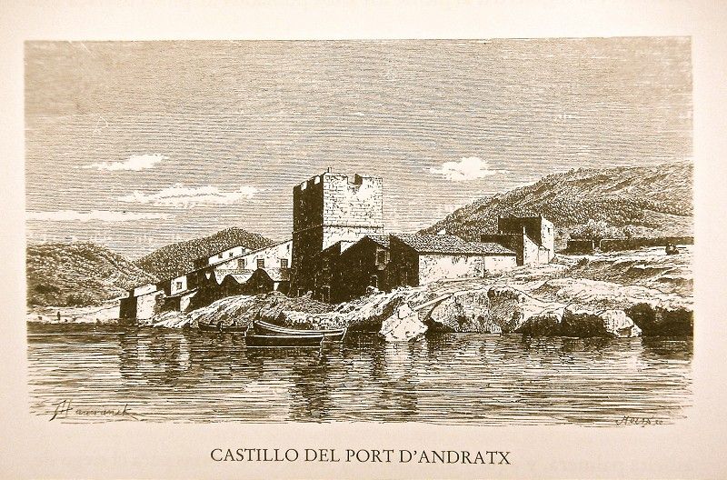 On the eastern shore of Andratx’s port, a small settlement has been established at the end of a small valley due to the soap factories installed there. They are single-story houses, the majority small and some of which, especially those near the port, have a vaulted ceiling. Next to them is the old tower measuring 7 “varas” high and known as Castillo del Puerto (Port Castle) or Torre de Sant Francesc (Saint Francis Tower).
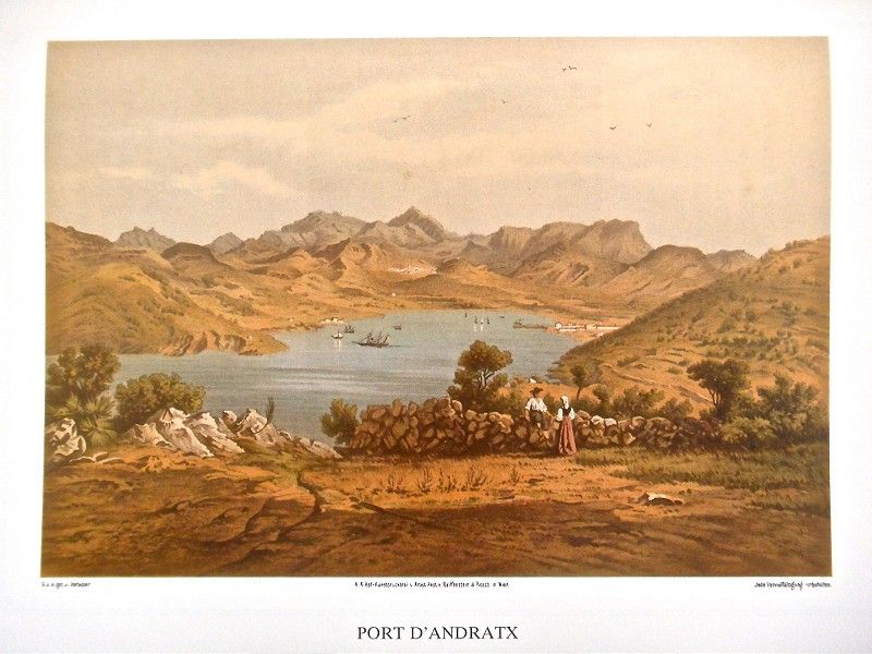 Next to it is the large soap factory belonging to Gabriel Valent, followed later by fishermen’s shacks lined up along the irregularly-shaped sandstone pier. Then comes a type of plaza with more shacks. A bit farther is Antoni Valent’s soap factory, above which is Bosc’s factory.
To the west of Andratx is the area known as Sa Font, populated by olive and almond trees and through which the road to s’Arracó leads.
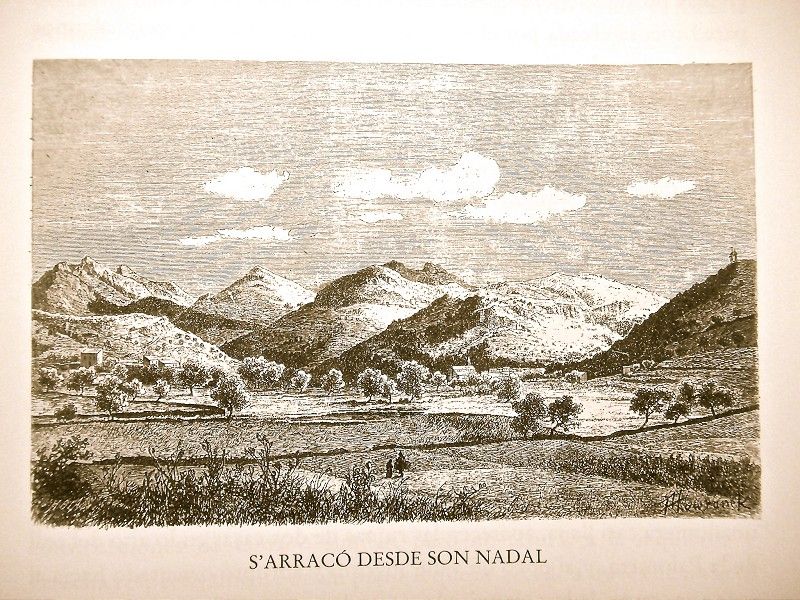
 In addition to the path from the road to Andratx which leads to s’Arracó, there is another one which communicates with the valley and along which the Torrent de s’Arracó stream runs. The path runs through Son Nadal, between a hill with a mill to the left and a raised pine grove on the right. It winds along, following the shape of the creek bed which, not that long ago, was the cause of so much damage. The broad terrain is populated by almond, olive, carob and black poplar trees before opening up notably behind a large lime oven. Our excursion continues now downwards between hills.
It takes us more than half an hour to get from S’Arracó to Sant Telm. The path crosses the river just after leaving the town, cuts through the valley and over a gulley populated by myrtle. It ignores a path opening to the left and winds upwards along rocky terrain scattered with fan palms. The path is increasingly steep and difficult.
My small Sant Telm estate is framed by the stream is on this side, other covered in pines and the sea to the west. It is an idyllic place, one of the prettiest on Mallorca, solitary and remote as no path leads to it.
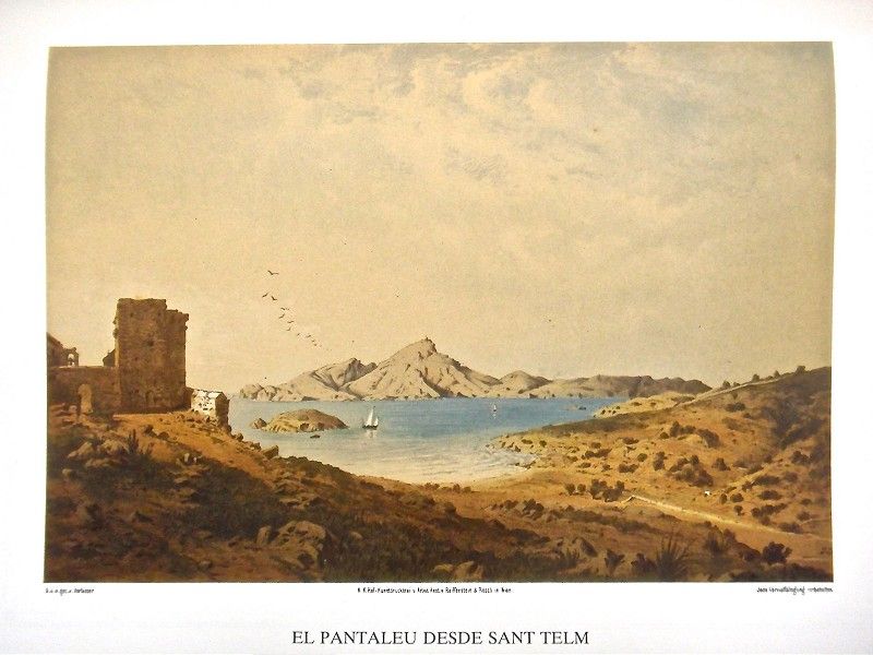 The square tower or Castell de Sant Telm was built in 1581 to defend Andratx. According to documents from the time, its construction was made possible by the money obtained for a shipwreck in territory belonging to the Bishop of Barcelona and the contribution of 1,000 pounds from Mallorca’s trade guild which agreed to build this one and the Dragonera Tower. It is a powerful building made of sandstone blocks, measuring 9 “varas” wide and the same as many high, with numerous arrow-slits. Attached on the west side is an “aljub” (cistern), today converted into a stable. The tower was once accessible via a patio and a simple spiral staircase, while the rounded arch that once served as an entrance was blocked by a wall, filled with sand in between. I had the wall removed, and, today, an interior staircase leads to the platform still protected to this day by a cannon. The view available from her, especially of Freu de la Dragonera, is marvelous, with the rocky island dominated by its tall lighthouse and historic Pantaleu Islet, along Sant Telm, the first on which Jaume I the Conqueror of Mallorca set foot.
We descend finally to sunbathe on this beach, the prettiest on Mallorca and very appropriate as well to bathe in the sea. It is the only healthy one since the other sandy shores of Palma Bay, Alcúdia, Pollença, and even Artà border on swampy land.
In the first direction, our backs turned to a promontory covered in pine trees which then stretches out into the sea, we come to the Cala Conills stream bed, the edge of Sant Telm and the place where fishermen meet to dye their nets. If, by contrast, we head north, from the other side of Sant Telm, a path descends and crosses over the Punta Blanca bed and continues in a straight line, not far from the sea, until reaching the slopes sprinkled with groups of pine trees."
Archduke Ludwig Salvator of Austria.Las Baleares por la palabra y el grabado. Majorca: The island. Ed. Sa Nostra, Caja de Baleares. Palma de Mallorca. 1982.
Photos