


From Pollença to Mancor and Biniamar

"Near Hostalet the path splits towards the Can Sion farm along rocky soil. Its monotony is barely broken by some or another olive or carob tree. It carries on along a pool which we cross to finally reach Can Sion after passing by a well. The farm is at the entrance of the valley. Fig and almond trees now alternate on terraces spread out along the hill known by the name of Ses Covases and overlooking the house. It is mostly modest, and, above the clock which presides over the half-point arched doorway, we can read the date, 1787. The entrance is guarded by two old lemon trees. Can Simon also has a beautiful cave with stalagmites. You reach the cave in the valley after passing along a small garden with fruit trees and some orange trees watered by a nearby spring. You then continue along the bed of a creek until crossing a grove of Holm oaks, some of which are quite notable in size.
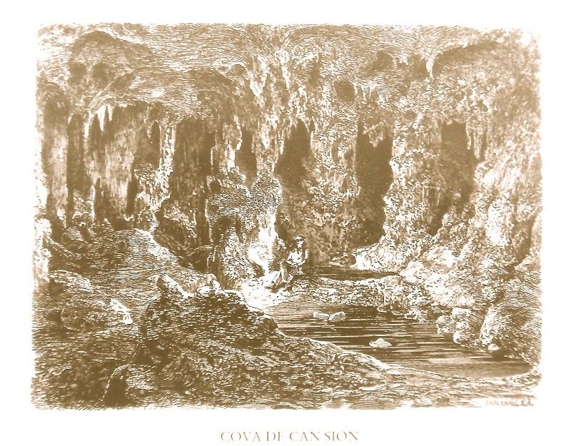 The path now continues with difficulty along the stepped stream bed. From the mouth of the cave, surrounded by tall crags, there is a splendid view of the valley and the plain up to Puig de Sant Salvador. The cave entrance is shaped like a wide ogive which, just open entering, reveals to our eyes large and beautiful stalagmites like stony cauliflowers in seasoning. We move amongst flat, slippery rocks and then a pool of water followed by another, deeper one called Sala des Trull, where the pool forms a type of natural pond. We then soon descend into a cavern in which the stalagmites reach the ceiling: white and so wet, we might think they were made of fine silver. At the back of the cave, the ground becomes muddy and dotted with isolated pillars seeking out the ceiling, seemingly appearing to form enormous arrowheads.
A path starts in front of Es Fangar which leads to Biniatró, an estate belonging to the Bennàssar family and one of the oldest farmhouses. We aim to see it in detail as it is one of the best cultivated and preserved farmsteads on the island, something not surprising given that it has been the object of special care and attention for various generations of the same family. A pretty copse of Holm oaks extends before our eyes to the door of the house, the latter hiding the chain of mountains at its back. The house, rebuilt in 1866, is very large, with ten windows on its facade, a main hall with three interior arches and four half-point arches as the entrance. It also has a patio with rooms on one and another side and a staircase made of red marble from Son Corró de Campanet. The house has a good “tafona” with a central pilaster and four diminished arches. Behind it is an “aljub” cistern which provides water to the “tafona” flourmill and also connects to the patio cistern for domestic consumption.
An excellent path descends from the house into the valley until Pla de Taló where the stream of the same name flows.
We stick to the course of the Torrent de Sant Miquel. Bordering along elms, we soon come to the small church with that same name. This public church, in the past the parish for the municipality of Campanet, was founded in the first years of the Conquest, apparently named and dedicated to Saint Michael in a papal bull issued by Innocence IV in 1248. It was the second church founded at that time outside the city, and many believe that it was a mosque before that.
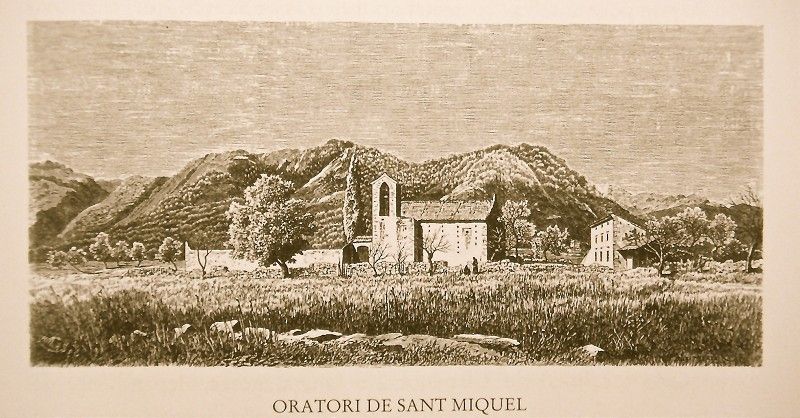 The building’s exterior is extremely simple, with an atrium and modern ceiling and, towards the back, a bell tower in ruins and the remains of a blind pointed arch. In the half-point arch crowned by a small statue of Saint Michael we can read the following inscription in red letters: “A 21. Setembre de 1607 pujaren la Campana” (on September 21, 1607, the bell was hung). Underneath is another inscription which says: “Die 14. Febrero 1799 pujaren la Campana” (on February 14, 1799, the bell was hung). The interior, which you reach down four steps, is supported on two pointed arches which, in turn, supports a simple ceiling. The Renaissance altar has three images of saints Michael, Sebastian and Anthony, respectively. The existing gate on the right part of the second arch is curious. It’s square, and between the three blunt corners are representations of Saint Peter, Justice and Saint John. At the foot of a pyramid-shaped base, noteworthy is the presence of a beautiful demonic head.
A bridge crosses the road behind Sant Miquel, the stream hidden by shrubs and lined by elms and black poplars.
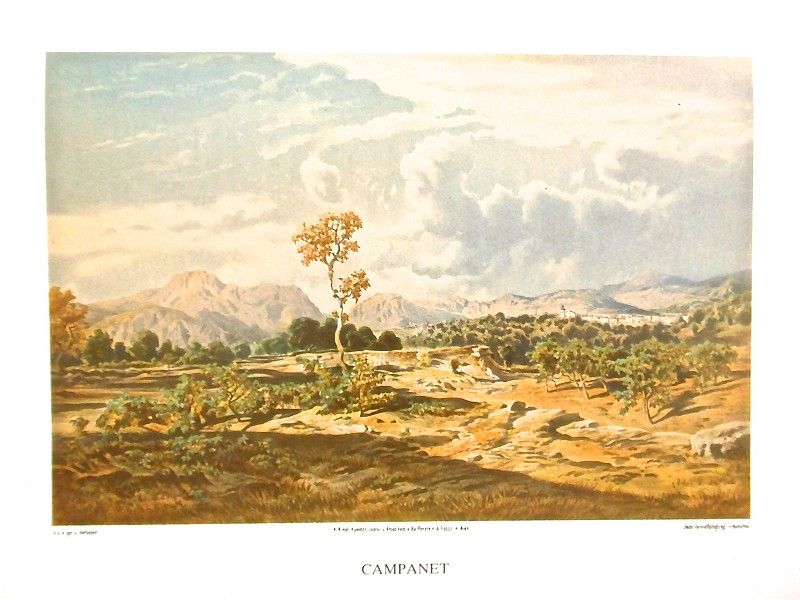
 Campanet is found on a knoll covered in part by olive trees and carob trees the other part. It’s crowned by various windmills which, on the northern side, serve as a backdrop for the majestic profile of the Serra range. The town has 1,821 inhabitants and 672 houses, 49 of which are uninhabited. Almost all the houses are one-story tall, their walls not whitewashed. The majority have a large door with rounded arch and windows with a cornice. Here and there, some stand out for their Renaissance style. In the plaza occupying the center of the town, there are some recent constructions with balconies and blinds. The parish church is also found here. It has an ogive arch portal and a beautiful Gothic rosette. To the right of the facade is a square, seven-story bell tower, the last two with ogive arch windows to the four winds. The fifth story has a clock, and the seventh is crowned by a pyramid-shaped crest which rises up to 166.94 m above sea level. From the tower there is a wide panoramic view of the surroundings, the valley of Son Garau with the houses at Biniatró, and the Sant Miquel and Ullastrar peaks, the limit of the valley heading towards Pollença. We can also see the two paths from Lluc passing through Castell and Monnàber, respectively. The second, the closest one, is practically only accessible on foot. The church’s interior holds up its dome with seven ribbed arches which cross at simple keystones, the ribs starting from the arches where they support their shafts on a solid cornice held up, in turn, by smooth Romanesque columns. The church’s main altar widens longitudinally, and there are five side chapels framed by their respective half-point arches. The most ornate one is the third on the left dedicated to Saint Victorian, martyr, whose relics Cardinal Despuig brought from Rome in 1807 and were venerated in the Ullaró chapel until the month of April, 1823.
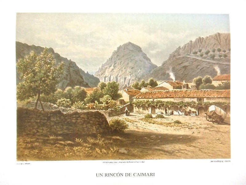
Also starting in Campanet is the poor Caimari path, with a steep descent as soon as it leaves the town and a soft curve to the left. To the right are two more paths and the houses belonging to the Possessió de s’Alqueria Petita (small farmhouse estate) and, to the left, a shed and numerous troughs. The olive trees, the oldest examples found in the existing groves at the base of the hill, are followed by almond trees amongst which mulberries grow here and there. Farther on are the carob trees which, along with the olive grove, make up the primary vegetation here spotted with exuberant fig and service trees. Turning to the right, we come to the no better path to Moscari, a miniscule village with 403 inhabitants and 62 houses found on a knoll with the sharp shapes of the majestic Puig de Lluc serving as backdrop.
We abandon Moscari by the Carrer de Campanet path to go to the nearby town of Caimari. The difficult trail first moves upwards along a slope populated by olive and carob trees and some Holm oaks. It then turns right, offering us a vast view of the undulating plain which extends to the very Puig de Randa peak.
 Caimari, known as Caimaritx at the time of the Conquest, is a small town with 847 inhabitants and 213 houses, thus making it larger than Moscari. Amongst its winding, small and irregularly paved streets with grey lime and reddish conglomerate formations are small groves of lemon trees. Worth noting is that many of the homes’ facades have trailing vines supported on stakes built into the wall. The town’s church has a triple bell tower rising up to 200.91 m above sea level, a sundial, small rosette and a simple portal to which three steps lead. The interior is tiny, its ceiling supported on three pointed arches which start from flat columns. It has two chapels on either side, and the main altar chapel widens at the back. Above the main entrance is a choir, its access found to the left of the door by the baptismal font.
To go from Caimari to Selva, only 1.8 km away, we have to retrace our steps along the path from Moscari and turn later to the right. With 1,141 inhabitants and 510 houses, almost all one-story tall and only 17 with two, Selva is found partially and graciously on a knoll divided into terraces to the left and the higher ground above it. On a mount overlooking the town is the parish church which, according to some authors, was built in 1300, the date the town was founded by King Jaume II and twelve others. Originally it was a simple farmhouse by the name of Xilvar. No parish on Mallorca has as many suffragans as the Selva parish, specifically: Mancor, Caimari, Moscari and Biniamar. In front of the church is a well with a solitary cypress tree by its side. A staircase with 42 steps divided into three gardened stretches climbs up to the church. It is fairly large in size and preserves the old facade. It also has a bell tower and another square tower to the right. The latter’s left two stories have two ogive arch windows on each side and a terrace on top, giving it a particularly airy feel with its 230.68 m above sea level. A pointed arch portal leads to the interior whose dome is supported on six arches. The simple ribs once joined at the keystones and the shafts rested on consoles though today they are supported on their respective columns. Between each arch is a lancet arch window today, perhaps blind in origin. The choir is limited by six ribs sticking out and which start from a common keystone. The neo-Gothic main altar of sandstone blocks was inaugurated in September, 1883. There are six chapels on either side, the third on the right occupied by one of the entrances into the temple. They are closed above by simple ribs gathered at the keystone.
The road towards Mancor leaves Inca(¿¿Selva??) along Carrer de Biniamar street and soon passes by a branch to the left towards Biniamar. The entire area is dominated over by the imposing Puig Major de Lluc also known as Puig Massanella preceded by hills where olives and pine trees grow here and there.
Mancor is 7.7 km from Selva, gathered at the feet of some tall hills partially covered by carob trees growing in terraces. It has 1,382 inhabitants and 236 small houses with square doors preceded here and there by trailing vines. Especially on the sides of the town, there are abundant small groves of lemon trees and exuberant bitter orange trees. They’re small plantations but one stands out, if possible, for its particular abundance. Almost in the center of the town is a small plaza called Plaça del Baile (dance plaza).
San Juan Church, located in the stone-paved Plaça de la Concordia, has a central rosette and an octagonal tower to the left with a crest and vanes open to all the winds, a cornice at the base and crown rising up to 245.59 m above sea level. A simple portal leads to the interior, a simple nave with barrel vault ceiling supported on three arches. The main altar is in a chapel closed off by a half-point arch. There are three chapels on the left and two on the right along with the main choir, its conspicuous organ standing out.
On a conical knoll overlooking Mancor, the small Santa Lucía Church still stands. The partially path leading up to it is partially paved and tamped down in the other part. It winds up the slope between tall rocky walls bordered by olive trees, with the Signs of the Cross signaled on iron crosses. An image of Saint Lucy is venerated at the church. According to tradition, the statue was found in 1233 in a cave near the church’s current location. To the right is a side door in a half-point arch to which three steps lead. The covered hallway the door opens on to takes you to the guest quarter’s patio.
On a hill near Santa Lucía, a bit farther back, is the small Biniarroi estate. On the peak at 464.82 m above sea level is the San Antonio Abad monastery built in 1821 after the expulsion of the monks from Real, though no mass has been held here for some time.
Biniamar is 5.5 km from Selva and is a picturesque village of 482 inhabitants and 126 houses found at the base of some barren hills, its foothills barely covered by weeds. In times of the Moors, it was a well-known farmstead by the name of Abenaamar. Numerous almond and bitter orange trees as well as prickly pears circle the town in a beautiful green belt."
Archduke Ludwig Salvator of Austria. Las Baleares por la palabra y el grabado. Majorca: The island. Ed. Sa Nostra, Caja de Baleares. Palma de Mallorca. 1982.
Photos