


From Lluc to Pollença

"The road to Coll curves three times until opening onto the valley of Menut on the right dominated by the conspicuous “puig” of the same name in the middle of the forest.
To the right is Puig de Muntibudell, a conical hill with the famous Mossa Holm oak whose highly branched though half dead trunk has a 9-meter diameter. The Son Alzina house is found at the foot of a rocky hill. After crossing two separating walls, we move between wild olive trees and then an avenue of cultivated olive trees and finally along very rocky land. We then reach the white Femenia house at the base of Puig Caragolí, to the west of which the notable and notorious Puig Roig rises up to 1,002.93 m high.
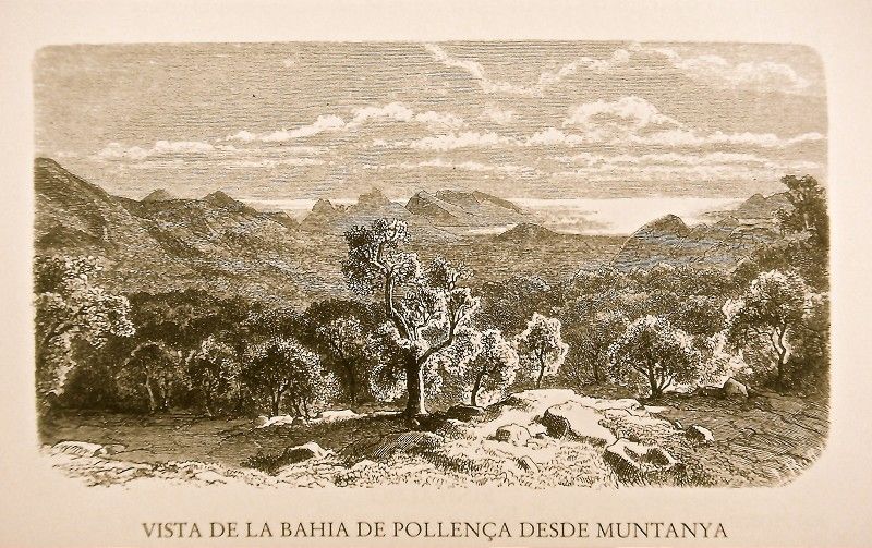
The path continues along the top part of the “hort” garden towards Femenia, leaving behind the fruit trees decorating the house. It crosses over a hill from which there is a view of the valley and opens at the foot of Puig Tomir and the top of Fartàritx to welcome Holm oaks which stand out between the rocks and olive trees in rows in the fields. We turn to the left and see Pollença’s Puig de la Mare de Déu and Cap Pinar. A few steps farther and our gazes encompasses the totality of Son Marc Valley, the Albercutx fortress, the peak, Cap del Pinar cape, the summit of Fartàritx and, in the forefront, the raised slope of Pujol de Muntanya serving as a type of rocky border for the plain.
 The path now descends sharply between stone walls and wild olive trees towards Mortitx. It’s soon replaced by another, no less rough path, though stepped and coarsely paved. It crosses through beautiful plantations of fig trees and leads us to Clot where there is a small house. Around it are streaked rocks, eroded by the rain. In front is a piece of very fertile land. As the valley has no exit, it is not rare for it at times to flood, filling up to a man’s height with water. The view from here of the conspicuous Puig Tomir accompanies our descent through olive groves along the lower foothills of Clot to the ever closer Mortitx.
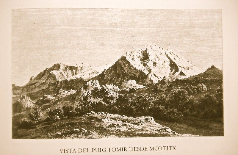
Puig Tomir’s initial slopes are very rocky, followed by steep rock walls barely dressed by one or another solitary Holm oak and totally bare at the summit. From the top is an extensive panoramic view of Puig Major and its foothills all the way to Puig de Cosconar and Puig Roig with the valley of Femenia and Binifaldó as well.
 Continuing on the Binifaldó path towards Pollença, we pass by a spring and, between Holm oaks, old fig and olive trees, is another spring. Meanwhile, our view rejoices with the sight of Puig Tomir and Puig Major in the distance and the exuberant and vigorous forest of Holm oaks and pine trees partially dressed with long moss.
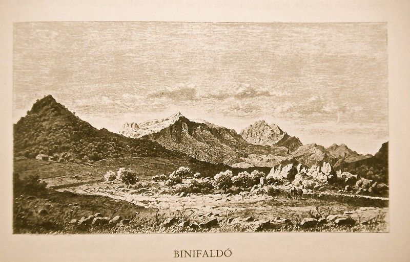
 To the left we pass by a winding, stepped and rocky path which runs through Holm oaks and pine groves towards the “possessió” called Muntanya, an estate watered by a spring which feeds a “safareig” basin higher up. The building is simple, with a pitched roof. In the numerous terraced “horts” (gardens) on both sides are cherry, orange, carob, fig and pomegranate trees, in addition to a variety of vegetables. At the base of the house, by contrast, is a large plantation of prickly pears with innumerable olive trees behind.
The path nears the edge of the forest again and takes us to a peaceful valley known as Vall d’En Marc, populated by olive, carob and fig trees amongst which numerous limestone crags are interspersed.
To our left is a group of houses, Clastra de Son Marc, where there is also a small chapel with a double crossing ceiling and Renaissance altar. The main Son Marc house has an ample inner patio, windows with balustrades and a quadrangular door in addition to a beautiful orange grove.
To the left is a property called Es Casals atop a knoll covered in rue. The path continues along the right between stone blocks and climbs winding and tiresomely towards Pedruixella Gran. From Sa Cova d’Enmig, where a large crag has been sliced from the outcropping, is a splendid view of that property and of the valley completely covered in olive trees and into which the Torrent des Casals empties. The path continues along the left towards Pedruixella Petit and then climbs once more towards Pedruixella Gran, formerly known as Rafal at the time of the Conquest.
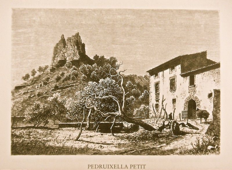
 Lower down, the valley of Pedruixella Petit opens up with the property of the same name in the center, surrounded by beautiful groves of olive and fig trees under two rocky formations called Sa Pedra Roja and Es Castellet, respectively. There are two old orange trees and a lemon tree in front of the house with a half-point arch, window with balcony and balustrade and roofed tower leaning heavily to the right. In back is a fountain and channel to take the water to the “tafona” flour mill.
The valley suddenly widens and becomes flatter. There is an orange grove to the right and, to the left, Son Grua at the base of some rocky foothills which shelter numerous farmhouses and tilled fields. From here begins the path to Ariant, the most steep and closed mountain valley on the island and which we propose visiting.
The rocky gorge at the beginning of the ascent is appropriately called Es Clot de l’Infern (Hell’s hole). The series of ravines called Pedruixella Gran and the heights of the “muntanya” (mountain) appear within sight. We cross over Esboldregat de Pedruixella, a rocky place on whose limestone formation some tenacious pine trees grow. From this privileged hill we can contemplate the well-known peaks of Puig Major de Sóller and the massive Puig Major de Lluc.
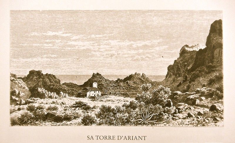
 The solitary house of Torre d’Ariant, under the shelter of a large rock at the base of the almost conical hill called Sa Penya des Corbs, has a window with an extremely pointed arch and a round tower over a slight embankment. Around it are Holm oaks, pine trees and some tilled fields, a small “safareig” basin fed by two fountains. There are also walnut, fig and various fruit trees up to the very foothills of Gironella followed by those of Puig Gros. Another clearing reveals still more tilled fields: in the valley separating Puig de Gironella and Puig Gros, there is a spring between black poplars, enlivening a large “hort” garden between walls. At its tallest elevation, the main channel bubbles next to an old mulberry shading a very aged mastic. From a promontory next to the tower is a splendid view of the west. The sheer, reddish outcropping has been eroded by the rains, giving place to the sea of rocks extending up to Mortixt.
We return to the Pollença path next to the point where we abandoned it near Son Grua. We cross over the channel used to guide the water extracted from the stream to supply the Son Serra property to the left of a bare hill.
The path, now in a worse state, crosses the rocky Torrent des Molins streambed. It’s dry in summer, and in winter it’s fed by a creek which descends from the heights to the left through the “possession” estates of Can Pontico and Can Llinàs, here and there running alongside solitary black poplars. A waterfall (“salt”) occasionally falls with the rains through the red and pierced crags at the foot of Can Llinàs. On the right we see a hollow between the beautiful mountain called Cuculla de Fartàritx with tilled fields up to the tallest parts of Serra de la Coma de Fartàritx, to which a path leads.
Amongst almond and fig trees and entwined grapevines, the path finally abandons the center of the valley and, leaving it along the left, reaches via Can Diable to the Holm oak grove on the Calvari hill in Pollença.
Pollença’s location in the middle of a very fertile and no less cultivated county and surrounded by low mountains is both important and charming. As it is the island’s most northeastern town, where the wind and the rains have made the land theirs, it should come as no surprise that rains are relatively frequent, a circumstance which has earned it the name of “Orinal del Cel” (“Heaven’s urinal), as well as the cause behind its exuberant vegetation. Pollença is also one of the places where the Mallorcan character has been preserved the most both in terms of how people talk as well as how they dress. Palma’s distance and the magnitude of the place have favored the development of its own society.
The main street is the Carrer Major which crosses the entire city, though its width varies. Pollença has several small plazas, the small Plaça de la Constitució also known as Plaça Nova with the miserable Town Hall, and, a bit beyond the market, the Placeta de l’Assolellador, with a stone cross. From the latter, the long Carrer del Roser Vell starts. There is also the Placeta de l’Almoina, at the southern end of the town and where we find a crater-shaped well. For the most part, the houses are small and two stories tall. We have counted up to 1,049, while 30 have just one story. By contrast, 578 consist of three stories, and 4 have still one more. The majority are made of “mitjans” stones, and their doors tend to open through a half-point segmental arch. It’s not uncommon to find the edges jagged, though simplicity is the most common. Windows tend to have a thick cornice like a parapet. And, if the house is made of stones, it tends to have a block frame above the portal. Renaissance balconies abound, nor do they lack the so-called “coronelles” arched windows.
Pollença’s main church is a very large square building, with windows onto the back part, and an unfinished main door but decorated with a beautiful Gothic rosette with stained glass. On the right is has a tower with two rows of Gothic windows, two on each side, top cincture with barbican and pyramid-shaped crowning, very similar to that of the Santa Creu Church in Palma. This tower measures 78.17 m above sea level. The spacious interior includes a large domed nave on six half-point arches and keystones with reliefs representing the Order of Malta coat of arms and where seven closing finishes join. The arches rest on a massive cornice over seven pedestals from a base which, in turn, rests on smooth Romanesque pillars. Six Gothic chapels open on both sides with ornate altars from the 18th century.
The main altar chapel is conch shaped. It’s presided over by an image of Mare de Déu dels Àngels. In the center are marble gravestones corresponding to monks. The oldest dates to 1861.
Pollença used to have two monasteries. Of their respective churches, only one is still in use, Mare de Déu del Roser, belonging to the Dominican Order as coadjutor of the main one. This monastery was founded in 1578, and its church, found on a small square, has a sandstone portal, a bell tower to the right and a rosette on the facade. Other than that, it is very modest. The interior reveals a choir above the main entrance and four chapels on each side. The second ones both serve as entrances into the temple, in addition to the two doors below the choir. Four half-point arches which start from a cornice on smooth columns support the vaulted ceiling. To the right of the church, attached, is the monastery with an ample cloister with 8 arches on the long sides and 6 on the other sides atop pseudo-Ionic columns which form pairs in the corners.
Previously belonging to the Knights of the Order of Malta, it was known as Puig d’En Porquer until the construction of the church when it began to be called Puig del Calvari. A good, recently constructed road climbs to the place after numerous curves. It substitutes the still existing old path which is wide but very steep and which started in a straight line from Monti-Sion. Two stretches of nine steps and a third with eleven leads to the small open plaza in front of the church. Today, the sloped hill and the five curves to get there represent the stations of the cross with iron crosses and descriptive ceramic tablets.
There is a lookout point onto Formentor and another onto Vall d’En Marc Valley. They rival each other for their rich panoramic views of natural lines which are both classic and pure. The top of Calvari peak is populated by agaves and cactus. It also features three windmills though today rendered useless due to the violence of the area’s gusting winds and the abundance of watermills in the vicinity.
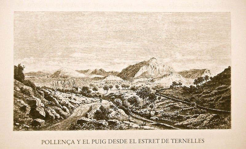
We first head north to discover the last valleys in the Serra range and their notable heights. We begin with the valley of Ternelles. The path starts in the town next to the Princesa wash basin. Here and there we see isolated houses, built, in part, of sandstone blocks. The garden soon reveals two tightly packed orange groves, s’Hort de Baix on the left and s’Hort d’En Sureda on the right.
 We pass by another mill called Molí d’En Cavaller and, after crossing through a grove of carob trees, we find ourselves in the vast valley of Estret de Ternelles, cut by a creek lined by innumerable fan palms and where the Molí de s’Estret mill is. The view of Pollença and the plain up to the low wall signaling the limit of Ternelles is truly splendid.
On a hill populated by olive trees, the Ternelles estate belonging to Catalina Villalonga stands out. It as a tower and an old house with a large, pointed-arch doorway and to which the “tafona” is attached. It’s on the front side of the living room. To the left are the stables. In front of the house is an “aljub” which gathers the water from the ceramic gutters sticking out on the walls. On the northern side is an old oak tree whose branches stretch out a considerable distance. The valley floor, pronouncedly reddish in color, consists of amorphous rocks profusely pocked with leucite and populated with a notable presence of Holm oaks. A dozen lively springs here supply Pollença with water. The valley is at its widest on the northern side where we also find the old hermitage. The truth is that the entire valley is the ideal spot for quiet seclusion, so remote from the mundane world, surrounded by tall hills bursting with vegetation and just a hint of Alcúdia Bay, a blue insert amongst the green slopes as if to heighten even further the longing.
A stone path leads to the hermitage. Leaving behind the stony pedestal of a cross, it climbs up along an avenue lined with cypresses. To the left of the path is a small torrent. The grove of fruit trees has its cherry and orange trees organized into various terraces. After a “safareig” (basin), we come to the atrium followed by a small stone-paved plaza. Here we find the church built of stone blocks, with a portal and tympanum. Above the latter, a rosette is preceded by a coat of arms with a dragon and cross above. The entire portal is crowned by a bell tower.
")
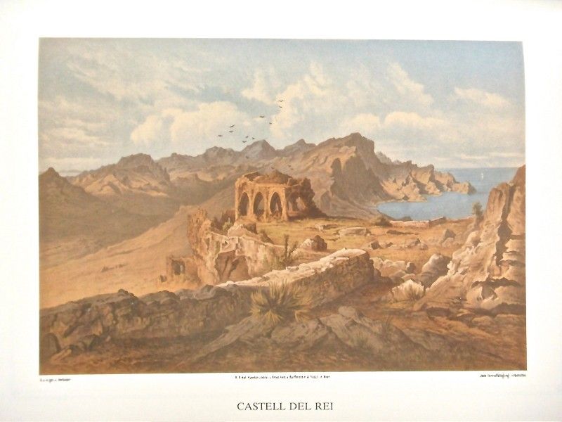
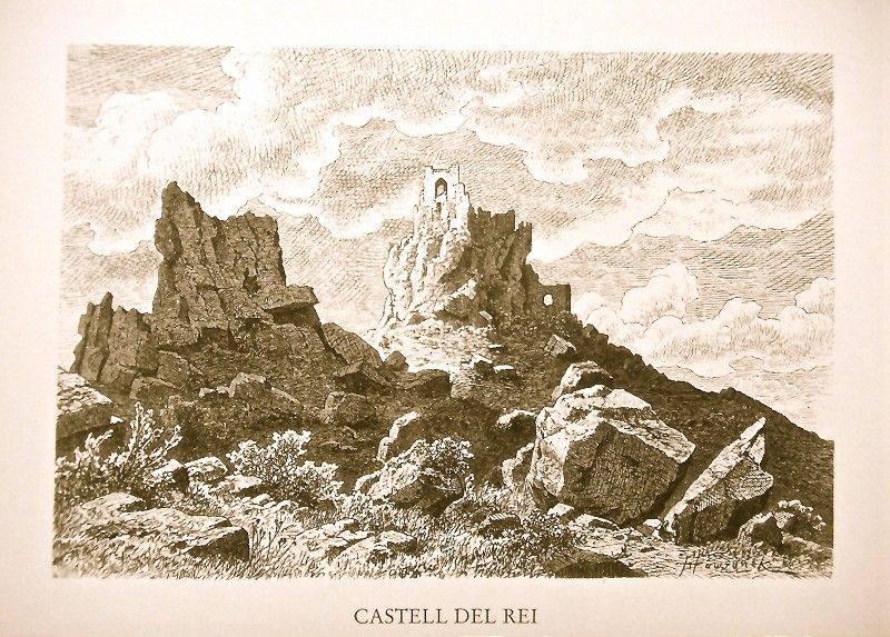
To get from Ternelles to Castell del Rei we follow the torrent along the edge of the forest until we reach the Font des Moliners spring which bubbles up from Ses Rotes Noves. It is one of the three most voluminous springs in the valley. We leave the path that leads to the hermitage from that part of the torrent and, following along the edge of a grove of pines, we come to the Hort des Carboner garden with its fruit trees and miniscule spring. Mastics, fan palms and “càrritx” (reeds) abound here and in the entire area as it is not subject to trade. Next comes the Coll des Cans with an abundant pine grove and La Rota with reddish soil. The valley narrows and then widens again to include numerous tilled fields and green pine groves. To the left of a rock we could say looks as if it had been artificially sculpted is Castell del Rei. To the right, by contrast, are Coll de Cuixac and then Na Vaques, both of which are very steep and semi-hidden by reeds.
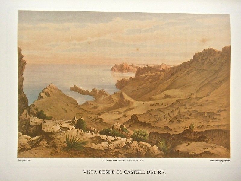 The castle wall curves around the rock, the tallest point facing the sea which, at that point, is far below. On the northeastern corner is the San Gabriel Chapel, a simple domed construction from which the panoramic view is tremendously rustic, both towards the sea as well as to Formentor and the lower valley. A small cave occupies the tallest point and offers a certainly dizzying view of the sea. Towards the interior, by contrast, Puig Tomir and the nearby Sant Salvador mountain, Colls d’Artà and the s’Albufera hollow all stand out.
The main building is on the western side of the barracks artificially carved into the rocks and supported by two ogive arches. Stone blocks and sandstone shore up the corners, creating domed rooms with simple ribs which cross in the center and rest on pilasters. At the southern entrance is a type of tower with dome and perimeter cornice with ridges. It’s joined to a wall which is straight here though rounded below in keeping with the tower of which it is a part. The opposite wall consists of a large rock, up which, legend has it, the Moors climbed to siege the castle. The tower is domed and surrounded by a corridor leading to the battlements, also present, though in fewer numbers, at a lower level. Only broom and rosemary occupy this now desolate place. Even taller are the remains of a tower-shaped room which, externally, still features the staircase to access a watchtower."
Archduke Ludwig Salvator of Austria. Las Baleares por la palabra y el grabado. Majorca: The island. Ed. Sa Nostra, Caja de Baleares. Palma de Mallorca. 1982.
Photos