


From Sóller to Lluc

"On the path that climbs towards Fornalutx, we make our entrance to the town of Sóller.
 The scenario created by the surroundings, the sea and, in short time, the lime Cornador mass is unique. A series of curves downhill take us to a hollow which ends at the “barranc” along a valley of black poplars to which a path next to the Salt des Cans waterfalls also leads. The land opens up more at the feet of the mountains and becomes fields. In the center is the Ofre house, occupied generally by shepherds who leave their sheep to pasture here and in summer by herds of horses. Near the house is a “tanca” (enclosure) used to grow vegetables. Amongst these are some lush pine trees. The path continues along the left of the valley where there is a spring with very clear water, Sa Font de s’Aritja, which empties into a trough for the animals.
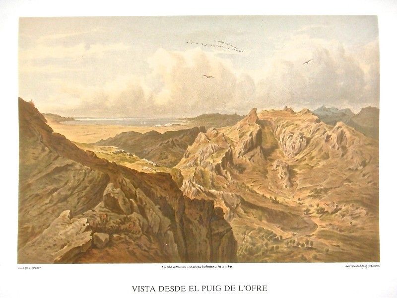 The path climbs over the only hill and begins its descent to the extensive Cúber and Almallutx Valley. The conical Puig de l’Ofre is most easily accessed precisely from this hill. The climb is rewarded with one of the most beautiful panoramic views. If not as broad as that offered from Puig Major, the wild natural setting endows this view with very special charm.
From the abovementioned hill, the path to Lluc descends to Cúber and Almallutx Valley, watered by a creek whose water borders a grove of black poplars and, to the right, an infinite number of sedges on the shore. On both sides of the valley we see fields of cereals in which there are six isolated mountain cabins belonging to Binimorat. All the walls are made of dry stone. Some have thatched roofs, while others are tiled.
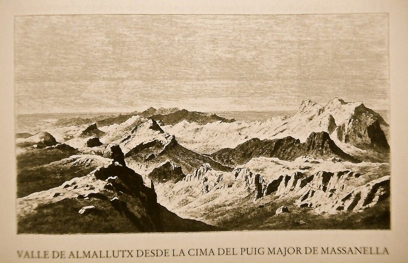
.jpg) Small streams converge towards the middle of the valley, and the surroundings, though barren, still have their charm, something to which the small farmhouses contribute. To the right we see some pine trees and, farther along, a lot of old Holm oaks and the Possessió d’Almallutx estate, notable for its mares and young mules, as well as an impossible-to-count number of sheep in summer. It is the old farmhouse called Almalutx, beside which the Moors founded an old settlement. The latter is now in ruins though it could still be seen, in particular its mosque, until the 16th century.
Small streams converge towards the middle of the valley, and the surroundings, though barren, still have their charm, something to which the small farmhouses contribute. To the right we see some pine trees and, farther along, a lot of old Holm oaks and the Possessió d’Almallutx estate, notable for its mares and young mules, as well as an impossible-to-count number of sheep in summer. It is the old farmhouse called Almalutx, beside which the Moors founded an old settlement. The latter is now in ruins though it could still be seen, in particular its mosque, until the 16th century.
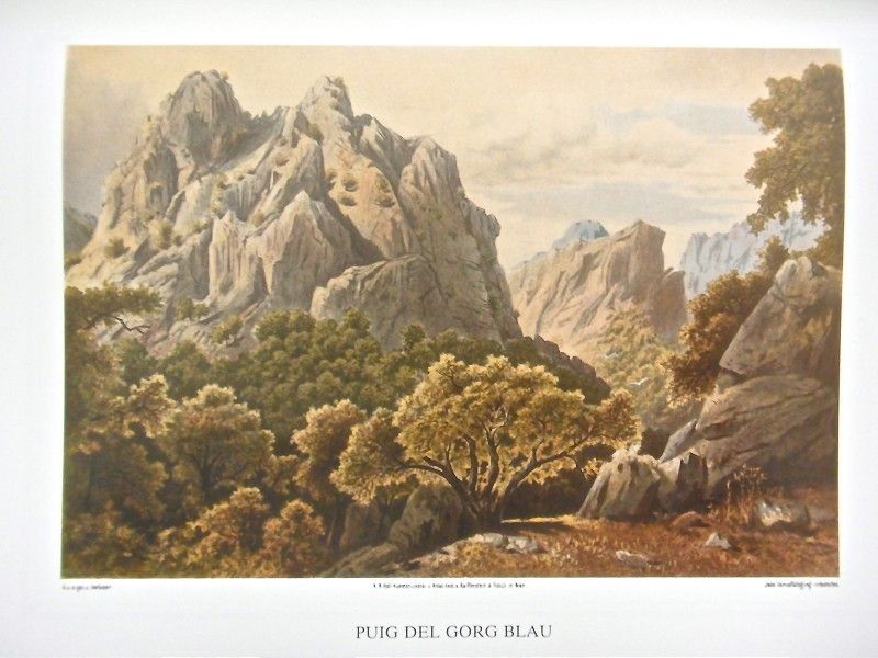 The valley is wide, and the path continues along a deep bed excavated by the current. The rocky sides seem very tall and steep, and the vivid, very cold and crystal-clear water gives off bluish-green reflections due to the depth of the water here. We’re talking about Gorg Blau (blue gorge), famous on the entire island and fed principally by the Font de Sa Roca spring which starts in Almallutx.
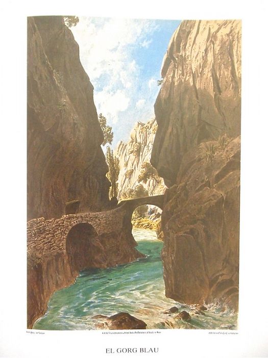 Climbing over the mountains which close off the valley, we can observe the sea in the distance and the new grey-colored rocky formations which frame the plain divided into fields and belonging to Cases Noves. Before reaching this property, we are once more offered a marvelous view of the colossal Puig Major and the deep Gorg Blau which our eyes happily follow to the deep Pareis canyon wall.
To the left, amongst rocky masses and lush Holm oaks, amidst an otherwise intact natural and very picturesque setting, is the Possessió d’Escorca estate belonging to Mr. Faust Gual de Tortella. It is one of the oldest farmsteads and was once known as Axcorca. Four old oak trees guard the entrance to this old estate which gives name to this entire region of Lluc. It is one of the largest on the island in terms of surface area though it barely has 300 inhabitants. The house is simple and modest and has a “clastra” (cloister). Next to it is a domed room and water reservoir which gathers the water from a voluminous nearby spring.
In the middle of Lluc’s verdant valley, at the feet of the rocky hills which, though not tall, are 525.75 m above sea level, is the Nuestra Señora de Lluc Church. The locality was declared a village by the name of Escorca though it only consists of the church, the attached school, a modest tobacconist’s shop and a couple of isolated houses.
According to an old tradition, after Jaume I’s conquest of the island, a young man named Lluc (Lucas) was herding his sheep nearby in 1239 or 1240 and soon saw lights and a great shine on one of the slopes of Escorca’s mountains. This was attributed to the Virgin Mary, or Verge de Lluc, and later declared the protector and patron saint of Mallorca. A small chapel was built next to the spot, and the means were gathered to be able to offer mass there.
An avenue with eight walnut trees on each side leads to the school. The road ends in an esplanade with a star-shaped fountain with two pails. To the left are various stables and other facilities and to the right a series of low buildings also used as stables.
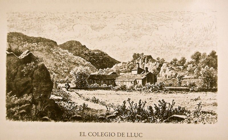 The old school which also served as an inn is a simple, two-story building and notably large. It has a facade with nine windows at varying heights. Above the simple entranceway accessed via six steps, is an image of the Virgin and a coat of arms.
The church is attached to the school on the rocky side. Externally frugal in terms of decoration, the facade onto the second inner patio has a rosette and an 18th century portal bearing the Sureda coat of arms. Above the church’s transversal nave is a rounded dome supported by 8 stanchions over their respective stone bases. It’s crowned by another, smaller dome with 8 small windows and supported by the same number of pillars. The dome’s keystone bears the date, 1657. Finishing wedges are in the corners. Worthy of note is the main altar chapel which narrows towards the back. It has golden adornments and an arch of triumph with the inscription: “Fundamente eius montibus sanctis”, Psalm 86.
The statue of Mare de Déu de Lluc is hidden in the Renaissance altar, but they will show it to you if you so request. It’s a small sculpture made of rough stone. She’s holding the Baby in her arms and wearing a tunic falling conically. There is a double-stepped exit behind the altar with iron handrail. Seven steps lead to the place where Mare de Déu is venerated and where they store the collection plate for small contributions.
There are pretty excursions from Lluc in any direction. Let’s direct our steps first to the highest peak in the area, Puig Major de Lluc also called Puig de Massanella. From the road to Guiz, a path starts which leads to the Camí de Sa Neu. This path crosses Coma Freda Valley and loses itself on Puig Major de Lluc. To our left is Caragolí del Guix, a peak which, with others, dominates the entire property. We cross over a separating wall and access the closed Coma Freda Valley at the feet of the sheer, barren walls of Puig Major. The path aligns itself with the torrent to cross through a forest of Holm oaks. We soon come to a wall, and the now steep and barren valley is barely covered by reeds, junipers, rockrose and thistles. The higher elevations, to which the paved path reaches, consist of a type of plain protected on either side by sheer walls covered in reeds. We leave the path that leads to the snow cabins to the right to climb up with difficulty to the summit. We pass by pointed outcroppings to finally reach the pass which allows us entry into Comellar de Ses Cases de Neu. All in all, the best pass is on the western side, Es Pas de N’Argentó, above which, to the east, the cliffs flatten into a small plain littered by the ruins of the snow cabin, Casa de Neu d’Amunt des Puig, which is more easily accessed by mule from Massanella forest.
 The entire Puig de Massanella slope seems spotted with beautiful yet tortured outcroppings. And just next to the tallest peak, abyssal Avenc drops. On the last peak of the here aromatic Puig Major (the second tallest after the northeastern peak some 300 m away), we still find the hole dug for geodesic triangulation purposes, situating this spot at 1,349.24 m above sea level.
If, instead, we head towards the sea from Lluc, the wildest and most solitary stage of this mountainous setting opens up before us. Immediately behind the church in Lluc, a path begins through a Holm oak forest and along a torrent to form a small “gorg” (gorge) called Gorg Blau. The path then descends to the wide valley of Aubarca to border along a Holm oak forest at the feet of the two connected peaks, Puig de Can Pontico and Puig Can Llobera.
Between Holm oaks and crossing over Torrent de Son Llobera which descends from Mossa, we come to the picturesque Ca s’Escrivà. We leave behind the olive groves of Sa Plana and continue down between the Holm oaks bordering the rocky Torrent de Pareis bed. On the other shore, there is a grove of fruit trees and some of the best grapes in Lluc. To the left is Son Colom with its beautiful trailing vine at its door and the “aljub” (cistern) behind. In front, in the middle of a copse of Holm oaks, is Son Colomí. Like the previous house, this one also has an “hort” and an oil mill.
To the right is the Roca Roja (red rock) outcropping which belongs to the Cosconar estate, though the latter property doesn’t have a house. It does have a cave in which workers live when harvesting the grains. This is also where we have to abandon the Torrentera, now with vertical walls and large rocks blocking our pass.
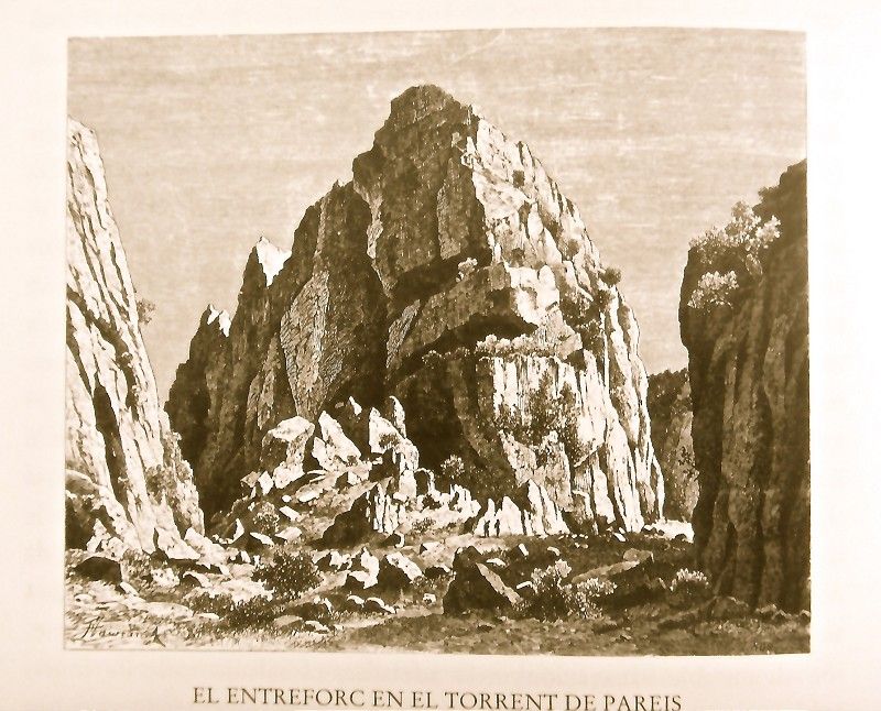 The slopes gain in height, the stream widens and the side outcroppings feature nearly horizontal stratifications caused by the rain. The setting is increasingly grandiose and impressive. The steep walls seem to converge up high, and a multitude of birds flutter in the countless bushes. Along with the flies, they are the only things that break the silence which reigns here. To the right is the Pas des Beverons pass which leads to Cosconar. A large outcropping in the stream is called Sa Penya des Burgar in consonance with the “xaragal” (ford) by the same name. In this spot, before suddenly narrowing towards Entreforc, the stream offers a marvelous view, without doubt the most spectacular one being of Torrent de Pareis.
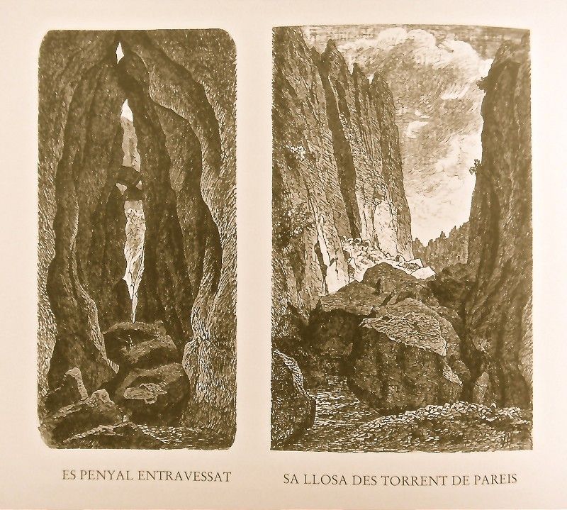 This is one of the wildest and most spectacular settings imaginable, with the background noise of the pigeons cooing with the cool. At the foot of the Penyal Entravessat mount is a deep gorge with crystal-clear water. It’s followed later by Sa Fosca and then Es Tu where the upper crack widens.
Descending, we come to two large rocks and, amongst them, a slab with two cavities inhabited by pigeons. To the left, the dark “gola” (entrance) of a deep cavern opens, dressed with large ferns. The landscape is crowned by large crags, determined to maintain the wild look of the scene. The streambed has been filling increasingly with more and more rocks, and walking is harder, so much so that travelers might be obliged to practice the art of not slipping. To the left we see the Cingle des Porcs crag with a cave and, not far from the stream, Sa Cova des Romegueral cave.
The bank has numerous holes, the domain of wild olive trees, “figueres bordes” (figs) and mastics, as well as chaste trees and reeds albeit in fewer numbers. Another cavity makes a bend, followed by another one, to the left, full of stalactites. We soon come to a large rocky esplanade with some pine trees. Behind these, finally, the torrent finds the sea through a cut in the rocks.
As Torrent de Pareis is more accessible, though today’s visit was difficult and it’s completely impossible in winter, it soon earned the reputation as one of the most beautiful mountain spots worth visiting on the island."
Archduke Ludwig Salvator of Austria. Las Baleares por la palabra y el grabado. Majorca: The island. Ed. Sa Nostra, Caja de Baleares. Palma de Mallorca. 1982.
Photos


.jpg)